The Urban Redevelopment Authority (URA) is in-charge of Singapore’s land use planning and conservation efforts.
Their mission is to create an endearing and sustainable home, filled with innovation and greenery, while preserving its heritage value, in partnership with the community.
As such, it conducts Long-Term Plan Reviews (LTPR) once every ten years after a year-long public engagement. Afterwards, it launched an exhibition showcasing the planning concepts and strategies that are meant to guide Singapore’s development for the next 50 years and beyond.
The newest exhibition is entitled “Space For Our Dreams”.
There are a total of seven pillars representing Singapore’s future urban environment— Live, Work, Play, Move, Cherish, Steward and Sustain.
Here are some facts about URA’s new long-term plans!
Redeveloping the Paya Lebar Air Base
Since the Paya Lebar Air Base (PLAB) will be relocated from the 2030s onwards, it frees up 800 hectares of land.
Among many of the long-term plans, this might be one of the grandest that the URA has unveiled, as it plans to make full use of the open land and transform it into a green live-work-play town.
Given that the PLAB has served many purposes in the past, from being the national airport, cargo-drop off and harbouring military aircrafts, its unique past will be integral to its future development.
For instance, the old airport warehouse will be redeveloped into a research space for new technologies, the old airport aircraft hangers will be turned into civic quarters of public amenities, where the existing buildings will be turned into a stadium, sports hub, secondary school and retail mail.
Naturally, as a nod to its old roots, an Air Force Museum will be fitted nicely into the space.
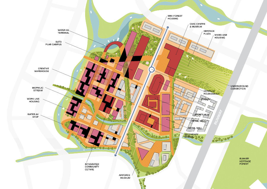
URA envisions PLAB as a town with people-centric mobility networks, which means that only autonomous vehicles and active mobility modes of transports are allowed in the neighbourhoods.
In terms of connectivity, pedestrian walkways and bicycle lanes will be woven into the neighbourhoods at ground level, with docking stations at every residential block. Green communal spaces will be planned along the pedestrian walkways.
Blue and Green Network
With regards to redevelopment, this renewed plot of land can be seen as a serious step towards promoting a sustainable living space, be it the surrounding biodiversity, energy usage, and water sustainability.
In order to embrace its “swampy history”, the Serangoon River will be connected to the two existing reservoirs nearby, namely the Tampines Quarry and Bedok Reservoir, through an urban estuary system.
The waterways will flow through with eleven waste-to-energy nodes implanted all around, cleansing the water and providing 20% of the PLAB’s energy requirements.
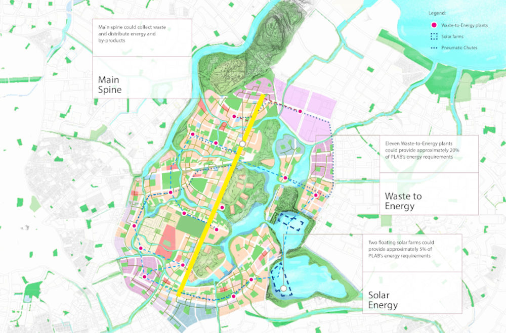
Solar panels will be installed on top of buildings, alongside solar panel farms, to help with the energy requirements too.
The new buildings will also be the first of its kind, made out of sustainable building materials like mass engineered timer and carbon infused concrete.
There will be rooftop gardens and vertical greenery to shade the buildings from the heat, which in turns reduces the energy needed for cooling. The rooftop gardens can also be used as a recreational avenue for urban gardening and helping with food availability.
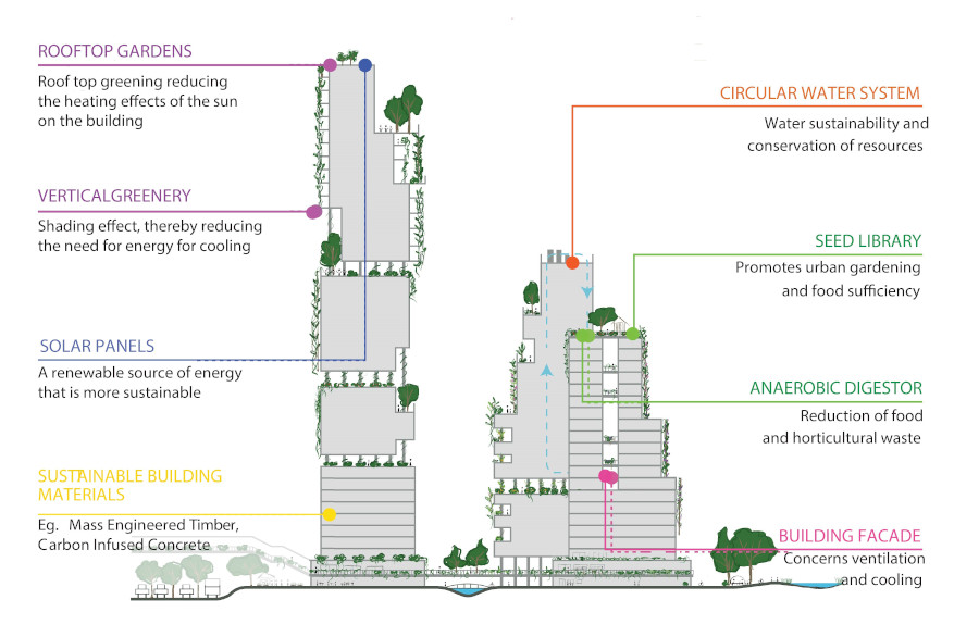
Another new initiative is the anaerobic digestor, which will serve to reduce horticulture waste.
Besides that, the buildings will run on a circular water system that promotes water sustainability and conservation of resources.
As for the residential and industrial buildings, they will be oriented to the prevailing wind direction such that they will form cooling wind corridors.
To ensure that households and the public amenities are easily accessible, new MRT stations will be built, planned along the circle like.
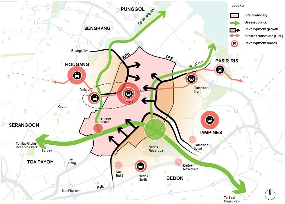
The biggest move would be the Green Corridor which will connect the Bedok Reservoir to MacRitchie Reservoir Park, East Coast Park, Sungei Serangoon in Punggol, and Sungei Api Api in Pasir Ris.
More Homes for New Needs and Aspirations
Although Singapore’s population continues to grow, it’s undeniable that the demographics and family dynamics are changing.
From large families formed in the 60s and 70s, the majority of households have downsized to smaller numbers.
During a March Parliament session, Mr Pritam Singh brought up the most recent government census which showed an increase in the number of singles between 25 and 34 compared to 2010.
And that’s to say nothing of the ageing population that Singapore is currently confronted with.
This means that there are more singles seeking out their own homes, in addition to young couples who wish to move out earlier and into bigger flats.
Hence, it’s necessary for the living spaces and environment to cater to these trends.
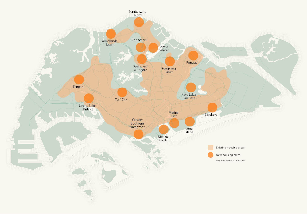
The key areas slated for redevelopment are mostly brownfields whose existing uses are getting phased out, but this provides opportunities for new housing.
This includes the Greater Southern Waterfront after the port has been moved away, and the Paya Lebar Air Base, which has been extensively covered above.
Since Singapore is small and land is scarce, there is also a need to expand into the undeveloped sites (greenfield), but it needs to be done with a steady and sensitive hand when the time comes around.
With regards to new housing, the Government aims to ensure that the new homes are built closer to key amenities such as transport and job nodes, which has been proven in the recent Build-To-Order exercise.
Another strategy that the URA is adopting to cater to the younger couples’ needs is to provide a wider variety of housing designs with open floor plans.
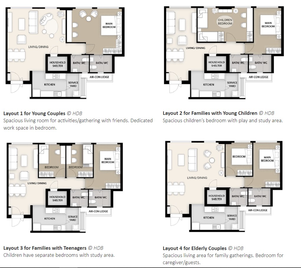
This will allow future owners to configure the space according to their needs and lifestyle.
Bringing Jobs Closer to Home
The URA intends to continue developing more polycentres across the island and renew the city centre in the long term to create more jobs closer to homes and to increase Singapore’s global competitiveness.
Essentially, “polycentres” or business nodes can be seen as industrial estates that will gradually integrate different facilities and amenities in a “vertical zoning” concept.
For example, the clean industrial activities can occupy the lower floors, while co-working spaces—which will have resources like the necessary office electronics and conference rooms—can take up the middle space and be a buffer to the residential areas above.
The benefits of having co-working spaces is that the leases tend to be more flexible (or short-term), and the provided digital assets can be shared, which is more cost-effective and convenient for smaller or start-up businesses.
The URA also plans to strategically position key polycentres to form “synergetic ecosystems” and efficiently tap into nearby transport links.
For instance, Jurong Lake District will be in walking distance to the Tuas Port and the research and development nodes in the west region, while the Northern Gateway, an area set aside for innovative sectors like agri-tech and cybersecurity, will have an enhanced connection to Johor Bahru via the Rapid Transit System link at Woodlands North.
Enhancing Recreational Options
In order to support an active and close-knit community, URA will strive to bring more recreational activities closer to home.
As part of the Dual-Use Scheme, it is suggested that school sports facilities can be opened to the community.
New and upgraded schools are being built with the intent of providing a greater variety of social and community spaces.
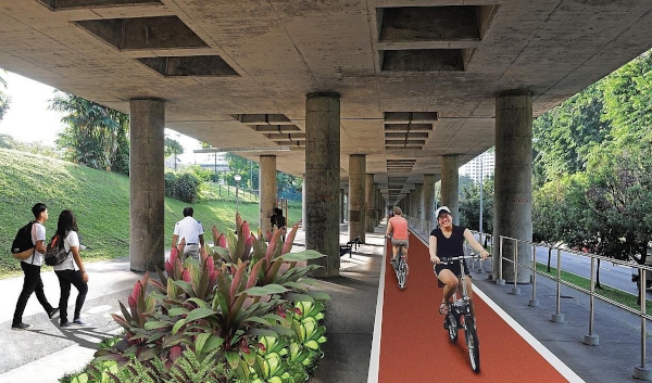
Under-utilised open spaces, such as rooftops of multi-storey car parks or the spaces under the MRT viaducts can be repurposed as community gardens or walking paths.
Additionally, commercial centres will be improved upon to make them one-stop hubs in central locations to offer various amenities.
It’s plausible to extend these centres outwards with attractive linear corridors in the future towns, which will bring necessary facilities closer to home, enliven the streetscape, and encourage active lifestyles.
Coastal Protection and Land Reclamation
Let’s be honest: Singapore is too small to let it sink.
In anticipation of the rising sea levels, the Government intends to reclaim “Long Island” which sits along the south-eastern coast of Singapore.
Not only will it offer protection against floods, the 15km extension from Marina East to Changi can also provide a new spot for leisure and recreation, similar to Marina Barrage.
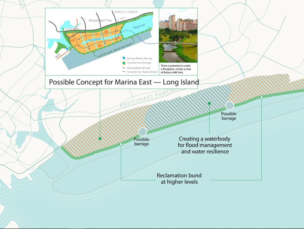
The Long Island concept was first introduced by Prime Minister Lee Hsien Loong during his National Day Rally in 2019, which is meant to be part of the $100 billion initiative to protect the country from rising sea levels.
The URA has since taken the time to study the area, proposing ways to integrate coastal protection measures.
Among other things, the URA suggests that a new reservoir can be created to enhance the country’s flood and water resilience, and be developed for new homes with unique coastal parks and recreational spaces.
To further optimise the land space, URA recommended the building of underground caverns to store goods or even house suitable industries.
By introducing an underground logistics system, it would allow goods to move efficiently while decreasing the congested traffic aboveground.
Heritage Preservation
To shape the identity of Singapore and endear the country to the future generation, the URA has also turned their attention towards the preservation of Singapore’s heritage and sites to widen the appreciation of our shared history and ingrain a sense of ownership for such spaces.
A Heritage and Identity Structure Plan was introduced, mapping out assets from monuments to heartland heritage areas.
One of the key aspects that the URA is proposing is called “Identity Corridors”, where five distinctive stretches around the island will be defined by varying characteristics, ranging from streetscapes to experiences that resonate with Singaporeans, both old and new.
The five corridors are:
- Historic East – The corridor of cycling streets that stretches to the East Coast will be enhanced with a new festive plaza near Geylang Serai. If at all possible, the cycling and pedestrian paths will be upgraded as well.
- Thompson-Kallang Corridor – Public spaces will be co-created with community, while the Kallang River will undergo improved accessibility and enhanced landscaping.
- Inner Ring – More walking and cycling spaces can be introduced to motivate citizens to explore different neighbourhoods along Zion, Kim Seng, Scotts, Newton, Moulmein, Balestier, Lavender, and Crawford Roads.
- Rail Corridor – A co-vision of activity spaces along the corridor to add on to ongoing works to enhance accessibility and greenery.
- Southern Ridges and the Coast – The 10-kilometre promenade can be shaped into a distinctive public space as it connects the Great Southern Waterfront to the rest of the area.
Read Also:
- M’sian Chops Up Mother into 15 Pieces After Fight Over Inheritance
- Food Stall in NTU Allegedly Had ‘Halal’ in Its Name But It’s Not Halal-Certified
- Ryan Tan Launched a New Travel YouTube Channel Called ‘Get Lost’
- Viral Footage of Men Fighting in Yishun Coffeeshop is Alleged Due to a Beer Lady
Featured Image: Urban Redevelopment Authority